 Brenta Dolomiti and Val di Non
The jagged peaks and glaciers northwest of Trento, the Dolomiti di Brenta, give this range the character of mountains wilder than the rest of the Dolomites.. The tourism industry is much less developed there, and reach them best from small towns: Madonna di Campiglio or MoWeno.
Mountaineers come here to climb the walls of Cima Tosa and Cima Brenta. For them, iron ladders were nailed to the rocks, called vie delle bochetle, that allow access to these walls. To pass these vie ferrate you need belay carbines and ropes, but not every tourist has to climb here. You can choose the right level of difficulty of the trail: less demanding routes lead through the valleys, and at height 3000 meters are paths, which, admittedly, are already tiring, but still easy to pass and do not require special skills. In total, the marked trails are enough for two to three days of high mountain hiking. The EPT Office in Trento issues a free guide to the Brenta Dolomites in English. This guide gives detailed locations of the vie delle bochette and estimated times of their passage.
Okolice Valle Rendena
Buses from Trento to Madonna bypass Monte Bondone, they drive along a winding road through a series of hills and villages, and turn to Valle Rendena in TIONE DI TRENTO, where a wilder landscape of pastures and forests begins. This quiet valley is a good place to rest. There are two small campsites on the edge of the buildings: one of them, Fae of Val Rendena (* 0465/57178), it is located between Pinzolo and Sant'Antonio di Mavignola. Small churches, such as Sant'Antonio, standing alone just in front of BORZAGO, they are decorated with cycles of frescoes by Baschenis, one of the many artists from Bergamo, working in this area. The Church of Santo Stefano in CARISOLO has frescoes on the outer wall, depicting the seven deadly sins, inside there is a painted legend about the passage of Charlemagne through the Val di Campiglio on the way to the coronation in Rome. Before reaching Madonna, several valleys go to the side, which lead high up the Adamella Massif.
The most beautiful of them, Val di Genewa, begins 4,5 kilometer from Carisolo and along a steep unpaved road it leads past a series of waterfalls, which look most impressive during the spring thaw. The most powerful of them is Cascata di Nardis, where the water falls in several streams on the granite wall of the mountain. From here to Bedola (1614 m.) is 13 kilometers , and three hours away, not far from the glaciers on Adamello, there is the Rifugio Citta di Trento refuge (2449 m.;0465/51193).
In CADERZONE, however, you can turn from the main valley of Valle Rendena to Malgra Campo, from where you can take the path no.230 to the small ponds of San Giuliano and Garzono (two and a half hours. expensive). There is a small shelter between the rates (the keys are taken at the bar in Caderzone).
Madonna di Campiglio
The main resort in the valley is MADONNA DI CAMPIGLIO, modern ski centre with plenty of chairlifts and downhill slopes of varying difficulty. Buses from Trento arrive at the main square and stop near the tourist office. In summer, the possibilities for hiking and climbing are almost endless and therefore a stay at Madonna is a good idea, to be able to get to the starting points of the trails easier. It is best to do this using the cable car, whose valley station is in Carlo Magno, 3 kilometers north of the village, and the upper one in Groste (See. below; codz. 8.30-13.00 and 14.00-17.30; 10 000 L one way). From Carlo Magno you can also take the Funma Cinque Laghi to the west, do Rifugio Pancugolo (2064 m.) in the Presanella band, from where, through Lago Ritorto and Lago Gelato, you can go on a five-hour trip back to the valley.
After the ski season, everyone leaves Madonna, except a few hikers. Most hotels usually ask for all or part of the upkeep, but in low season you can find favorable offers in some 3-star hotels (best to ask upon arrival). Away from the main road, east of the winter sports center, there are several cheaper accommodation options. Following the yellow signs leading to Rifugio Valesinalla, you pass by Garni Bucaneve (0465/41271), where bed and breakfast is paid 23 000 L per person. On the same route are Norma Garni (0465/41110) and Gianna (0465/41106), which are a bit more expensive (30 000 L).
Near Madonna there is a smaller ski resort, PINZOLO, which ski lifts can also be used on the basis of a ticket issued in Madonna. Pinzolo also has its own center with the church of San Vigilio, which is decorated with a sixteenth-century fresco depicting danse macabre.
Trails from Groste
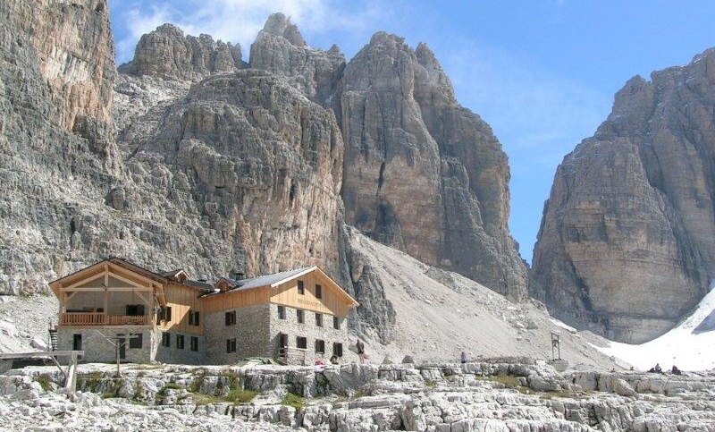
Having a good map of the area, you can plan your own route. Two interesting routes start in Groste (2437 m.), connected by cable car to Carlo Magno in Valle Rendena. Accommodation is offered by Rifugio Graffer (2261 m.;0465/41358), located near the upper station of the cable car and both routes. Trail no 316 leads from the cable car over the boulder-strewn slopes to the Sella and Tuckett huts (• 0465/41226). In the latter, already located hundreds of meters above the valley, you can eat dinner and relax on the panoramic veranda.
Trail no 328, which then becomes trail no 318 (called Sentiero Bogani), it starts right behind these shelters. On the way, you have to cross uncomfortable boulders, but then it goes easy, a path carved in the rock wall. At a distance of approx. four hours' walk from Groste, a Marian chapel was placed in a small ledge, in memory of those, who died on the surrounding peaks. Not far from here to the Rifugio Brentei (2182 m.; • 0465/41244), located halfway between Cima Brenta and Cima Tosa . Difficult climbing routes begin near the shelter, but after reaching the hostel most of the tourists are so tired, that he can only watch the Adamello glaciers glittering from beyond the deep gorge.
Next day, if someone is prepared to cross the snow-covered areas, you can go to Bocca di Brenta, then go to the other side of the ridge and follow trail no 319 go down to Molveno (3 Hours. 30 Min.). Otherwise, you can go back to Madonna by routes no. 318 and 316 (3 Hours. 30 Min.).
Molveno
Located on the lake, surrounded by the peaks of Brenta Alta, wioska MOLVENO, is a cheaper tourist base than Madonna. Through the tourist office you can find accommodation too 15 000-25 000 L per person, but the cheapest places fill up quickly, especially at the peak of the season. In the coastal Campeggio Spiaggia Lago di Mofoena (0461/586978) pays 4800 L per person and 7350 L per tent. It is a very comfortable place, but plenty of caravans parked here can be daunting.
From Molveno towards the Brenta massif there are several easy trails, which, although sometimes disappear and turn into vie ferrate leading through the rocks, but all these sections are marked on the maps, which makes it easier to plan trips. Wanting to go deep into the Brent range from this side, you can take the cable car from Molveno to Pradel (1500 m.), from where the trails lead in the shadow of Croz dell'Altissimo (2339 m.) through the beech-pine valley of Val delle Seghe. From there you can return by an easy circuitous route to Molveno (2 Hours. 30 Min.) or go higher, passing Rifugio Tosa (2439 m.) and Rifugio Tommaso Pedrotti (2491 m.; 0461/47316), but these routes already require greater mountaineering skills. The most outstanding of the nineteenth-century climbers, Francis Fox Tuckett, opened for others a new difficult route from Molveno to Cima Brenta, now called Bochetta di Tuckett. Because in his day, ice axes were not known yet, it climbed snowy slopes, using a ladder and a kind of ciupaga, and of the food he took with him pieces of meat and bottles of wine. Surrounding landscape, where Tuckett "wandered among the sloping rocks and white, brown and reddish stone spiers ”remained unchanged to this day, though Bochetta now leads down from the mountain pass past the Tuckett and Sella huts (See. above). Other trails bypass Cima Tosa and descend to PINZOLO, passing Rifugio Dodici Apostoli on the way (2469 m.; 0465/51309).
Val di Non
Stroma Val di Non, the terraced slopes of which are almost entirely covered with apple orchards, is located north of the Brenta massif. The most beautiful parts of the valley can be crossed by car, turning off the N43 road (leading from Trento to CLES at the end of the valley) on the side road to TUENNO. Cles can also be reached by bus or train, that run from Trento to Male. Cles is situated on the shores of the artificial lake Lago di Santa Giustina and is a special combination of the past and the present: there are many castles around the town, and to the northeast of it there is a great dam. It is worth visiting Castel Cles crowned with turrets, with interesting frescoes by Fogolin.
On the opposite side of the lake from Cles, 45 minutes walking uphill from SANZENO, Santuario di San Romedio rises above. It is a place on a cliff, where the legendary hermit Romedius lived with his bear, today a popular place of pilgrimage. The sanctuary consists of several churches, which were built in the 11th-18th centuries. The saint was to have a hermitage in the two upper chapels.
Cles is close to the Stelvio National Park. By car, it takes approx. an hour and a half through MALE and BAGNI DI RABBI or PEJO TERME (to both towns, turn off the N42). However, it is much easier to get to the park by going to Merano by bus.