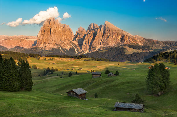
Grassy plains of Alpe di Siusi, stretching north of Bolzano, they are unusual because of their size (above 60 square kilometers) and its unusual location at the foot of the Sciliar massif (Schlern), high above the rest of the valley. Driving down the road through the valley, it is impossible to expect such a landscape.
By bus from Bolzano, takes you to SIUSI, from where you have to change to the next one to Alpe. The road leads through wide bends through the Hauenstein Forest, next to the ruins of the castle, which once belonged to the last Minnesinger of South Tyrol, Osvalda of Wolkenstein, and the church of San Valentino, topped with an onion-like dome (Sankt Valentiskirchlein). Bus route ends at SALTRIA (SALTNER), the center of these wetlands. It is an area virtually untouched by civilization, if you do not count the felling of trees. On the hard grass graze horses wrenching between swamps and streams, and here and there tufts of pine trees grow and lonely huts stand. From Alpe di Siusi there are paths to huts in the mountains, and in Saltria one of the few buildings are two hotels. The simpler of them is Brunelle (• 0471 /72940), where partial maintenance is paid for 33 000 L per person.
Sciliar (Schlern) and Sasso Lungo (Langkofel)
National park, which includes this area is called so, like the flat rocky mountain of Sciliar (Schlern). It consists of two peaks, Cima Euringer and Santner. There are trails from TIRES to Schlern (TIERS), FIE AM SCILIAR (VOLS AM SCHLERN) and SIUSI (SEIS). They all have long and steep sections of ascent to the top (2563 m.). Just below the summit is, built in years 80. XIX century, one of the first alpine huts of Rifugio Bolzano al Monte Pez (Schlernhaus; • 0471/616024; VI-kon. IX). Cable car from located above the UMS (UMES DI FIE) HOFERALP shortens the approach by approx.. 1000 m. In summer, the paths can be crowded, but in the evening, when the sharp contours of Sasso Lungo (Langkofel) they are covered with fog, most walkers disappear into the valleys.
The trail to the Sasso Lungo massif departs from the path between Saltria and Monte Pana, above located in Val Gardena Santa Cristina. In a few hours you can walk this trail to Rifugio Vincenza (Langkofelhutte; • 0471 /77315; Kon. VI-25IX), and from here another path descends the traverse to the Passo di Sella pass (Sellajoch).
Val Gardena (Grodnertal)
The Alpe plain is connected by hiking trails and cable cars to Val Gardena (Grodnertal), where there are plenty of not the latest accommodation houses and tourist coaches standing in front of them.
The main village in the valley, ORTISEI (SANKT URLICH), has been an important manufacturer of hand-carved wooden toys for centuries. Several families have been making one type of toys for years, and to this day, three thousand craftsmen in the village make furniture and religious statues.. Ortisei, however,, as well as the neighboring villages of SANTA CRISTINA and SELVA (WOLKENSTEIN), is now primarily a ski resort. Close from here to the Sella Ronda route. It consists of ski slopes and lifts and leads around the most important ski area in the Dolomites, Gruppo di Sella. This long route takes at least one whole day. You can return to Bolzano by bus or take the opportunity to go the other way, towards Passo di Sella or Passo di Gardena.